Route experience
Stage 3 with a progressive profile: walk at a steady pace and expect transitions between village, coast, and connectors.
Sea pause
Fons Aretusa → pine grove → Copanello Lido
From the spring to Copanello Lido via the nearby tower, reaching the pine grove and beach for a first sea-level pause.
A quick visual look at key moments from this stage.
A practical read of this stage: context, on-route experience, and arrival connection.
Fons Aretusa → pine grove → Copanello Lido
Route experience
Stage 3 with a progressive profile: walk at a steady pace and expect transitions between village, coast, and connectors.
Historical/civic value
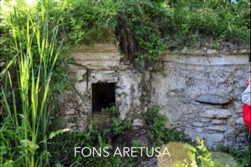
Fons Aretusa remains the narrative anchor of this coastal approach, linked to the Via Randa-Casino Pepe system.
Naturalistic/archaeological value
Coastal pine grove and sea access: a short segment that highlights the hill-to-coast transition.
What to notice
Notice the historical and landscape landmarks referenced for this stage, and use the gallery images to recognize key passages.
Services and opportunities
Copanello Lido provides first opportunities for pause, food, and beach services.
Main criticalities
Connector wayfinding between spring, pine grove, and coast access still needs clearer readability.
GPS and status note
Short segment with available coordinates; rely on local route description where the trace remains schematic.
Secondary technical summary for this stage.
Practical and safety guidance to walk this stage with confidence.
Save or open this page before you begin. Some areas may have weak signal.
Practical tip: Sterrato e asfalto. Difficulty: easy. Duration: 25–35 min.
This official route track is provided for orientation. Always follow local signage, current conditions, and local guidance.
Official stage track coming soon.
Open the start point in external maps when coordinates are available.
GPS and status note: Short segment with available coordinates; rely on local route description where the trace remains schematic.
Coordinates: 38.7560, 16.5655
Useful nearby context: places, issues, and mapped signals.
Nearby issues
Fons Aretusa: clearer wayfinding is needed between the spring, pine grove, and coast
Wayfinding
low
View detailsCassiodoro area: sensitive point between crossing, coast access, and uphill connection
Access safety
high
View detailsVia Randa: drainage and walking surface still need consolidation
Access and surface
medium
View detailsNearby places
Copanello Lido
service
Fons Aretusa
poi
Cassiodoro Pools
landmark
Santa Maria Vetere
landmark
Operational signals linked to this stage.
CDV-CRIT-002 · Tappa 01 — Via Randa
Confermare segnaletica di discesa/risalita verso Copanello Lido e raccordo verso Motel.
Priority: medium
Status: Open
Notes: Rilevata dipendenza tra segmenti consecutivi nel modello repo.
Move to the previous or next stage.
Previous stage
2. Arches — Via Randa — Fons Aretusa
A panoramic descent along Via Randa to Fonte Aretusa, touching rural heritage sites and viewpoints over the north coast.
Next stage
4. Copanello Lido — Motel Gatti
Cross the pine grove and climb toward Motel Gatti, passing the old powder magazine and a high viewpoint over Copanello and the Gulf of Squillace.
Supporting this stage helps improve the public route experience.
Stage sponsor
An open space for families, citizens, businesses, and supporters who want to adopt a stage or a concrete need.
Support / sponsorSupport campaign
Available for local businesses interested in supporting the first sea-level arrival.
Support / sponsorMedia available for this stage.


