Route experience
About 4 km, mostly downhill (from town elevation to the coast). Mixed surface: historic paving, dirt stretches, and final asphalt connectors.
Camino stage
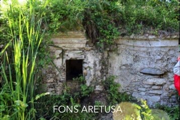
Roman Arches → Casino Pepe → Fons Aretusa → Copanello Lido
Panoramic descent from town to sea along historic Via Randa, with rural passages and views over the Gulf of Squillace down to Fons Aretusa and Copanello Lido.
A quick visual look at key moments from this stage.
A practical read of this stage: context, on-route experience, and arrival connection.
Roman Arches → Casino Pepe → Fons Aretusa → Copanello Lido
Route experience
About 4 km, mostly downhill (from town elevation to the coast). Mixed surface: historic paving, dirt stretches, and final asphalt connectors.
Historical/civic value
Via Randa preserves a long continuity as the town-to-coast connector; Casino Pepe and Fons Aretusa stand out as local heritage landmarks.
Naturalistic/archaeological value
Mediterranean scrub, biodiversity, and coastal outlooks accompany the descent, linking hillside, headland, and sea.
What to notice
Casino Pepe, the Fons Aretusa fountain, gulf viewpoints, and the final transition toward Copanello Lido bay.
Services and opportunities
Stop options at farm-based activities (by booking) and beach/food services in Copanello Lido.
Main criticalities
Grass cutting/cleaning, resting-point setup, SS106 crossing, and wayfinding remain priority operational items.
GPS and status note
Stage coordinates are available; the GPS trace is still marked as operationally under consolidation.
Secondary technical summary for this stage.
Practical and safety guidance to walk this stage with confidence.
Save or open this page before you begin. Some areas may have weak signal.
Practical tip: Basolato storico, sterrato e asfalto nei tratti di collegamento. Difficulty: moderate. Duration: Duration pending.
This official route track is provided for orientation. Always follow local signage, current conditions, and local guidance.
Official stage track coming soon.
Open the start point in external maps when coordinates are available.
GPS and status note: Stage coordinates are available; the GPS trace is still marked as operationally under consolidation.
Coordinates: 38.7604, 16.5595
Useful nearby context: places, issues, and mapped signals.
Nearby issues
Fons Aretusa: clearer wayfinding is needed between the spring, pine grove, and coast
Wayfinding
low
View detailsVia Randa: drainage and walking surface still need consolidation
Access and surface
medium
View detailsCassiodoro area: sensitive point between crossing, coast access, and uphill connection
Access safety
high
View detailsNearby places
Fons Aretusa
poi
Copanello Lido
service
Santa Maria Vetere
landmark
Cassiodoro Pools
landmark
Operational signals linked to this stage.
CDV-CRIT-001 · Tappa 01 — Via Randa
Verificare continuità e leggibilità del tracciato nei raccordi misti basolato/sterrato/asfalto.
Priority: high
Status: Open
Notes: Checklist Maggio 2026: punto inserito in forma sanificata, senza riferimenti sensibili.
Move to the previous or next stage.
Previous stage
1. Start — Roman Arches & Mother Church
Start in historic Stalettì at the Roman arches and the ruins of the Mother Church—your welcome gate to the whole loop.
Next stage
3. Fons Aretusa — Copanello Lido
From the spring to Copanello Lido via the nearby tower, reaching the pine grove and beach for a first sea-level pause.
Supporting this stage helps improve the public route experience.
Stage sponsor
Available for sponsors, donors, and local partners.
Support / sponsorSupport campaign
Available for sponsors, donors, and local partners.
Support / sponsorMedia available for this stage.


