Overview
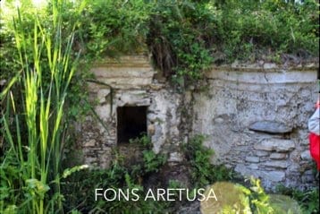
Panoramic descent from town to sea along historic Via Randa, with rural passages and views over the Gulf of Squillace down to Fons Aretusa and Copanello Lido.
Route experience
About 4 km, mostly downhill (from town elevation to the coast). Mixed surface: historic paving, dirt stretches, and final asphalt connectors.
Historical/civic value
Via Randa preserves a long continuity as the town-to-coast connector; Casino Pepe and Fons Aretusa stand out as local heritage landmarks.
Naturalistic/archaeological value
Mediterranean scrub, biodiversity, and coastal outlooks accompany the descent, linking hillside, headland, and sea.
What to notice
Casino Pepe, the Fons Aretusa fountain, gulf viewpoints, and the final transition toward Copanello Lido bay.
Services and opportunities
Stop options at farm-based activities (by booking) and beach/food services in Copanello Lido.
Main criticalities
Grass cutting/cleaning, resting-point setup, SS106 crossing, and wayfinding remain priority operational items.
GPS and status note
Stage coordinates are available; the GPS trace is still marked as operationally under consolidation.